Resources from ESRI (ArcGIS)
ESRI (the software company that makes ArcGIS products) offers a number of online courses. Many of these courses are available for free to students and staff at Massey University through our organisational license agreement with ESRI. The best way to find a course is to search their course catalog. You will need an ESRI account to start the course.
To link your Massey account with ESRI go to esri.com and sign in using the Organization – enter massey for the organization and then click Massey University
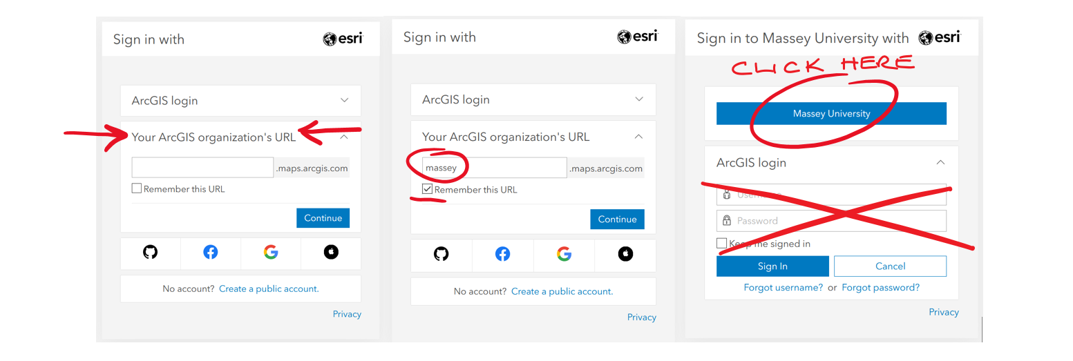
If you are offsite you will be directed automatically to a Massey login page.
For the software installer for ArcGIS Pro contact Massey’s ESRI site administrator Matthew Irwin m.e.irwin@massey.ac.nz
Resources for QGIS
QGIS is a free and open source GIS software with a world-wide user community. Resources and information on support groups are available through their website. There are various websites that offer tutorials for learning QGIS. Two are QGIS Tutorials and Tips and GISGeography
Python Resources
There are a number of Python Libraries for working with spatial data, some of the most common are Arcpy (for ESRI ArcGIS), the geopandas library, and the GDAL/OGR library. Links to information about these libraries and more can be found at GISGeography.
Spatial Database Resources
Several widely used databases support geospatial data, including rich models for representing geometry information, together with tools for spatial querying, indexing and some forms of analysis. Commercial database examples include Oracle Spatial and a common open source option is PostGIS (which extends PostgreSQL). The popular MySQL database also supports spatial objects. A longer list of spatial database management systems can be found here.
Remote Sensing Resources
Google Earth Engine is free-to-use cloud computation platform to access and analyse large volume of remote sensing data. The data archives consist of multispectral imagery, including MODIS, Sentinel-2 and Landsat and ASTER) to solve Geological and Environmental issues. To interact with the data and perform analytics, Python or JavaScript programming skills are required. Great resources are available in the documentation. Useful links:
- Google Earth: https://earthengine.google.com/
- GEE documentation: https://developers.google.com/earth-engine/guides/getstarted
- ASTER: https://terra.nasa.gov/data/aster-data
- Landsat: https://landsat.gsfc.nasa.gov/
- MODIS: https://modis.gsfc.nasa.gov/
- Sentinel-2: https://dataspace.copernicus.eu/data-collections/copernicus-sentinel-data/sentinel-2
Drone Information
Remotely piloted aircraft (RPA) or Unpersoned Aerial Vehicles (UAV) are used in a range of disciplines and careers to conduct research, monitor infrastructure, shape planning, assist with pest management and site testing, and much more. UAVs are also used in humanities and social sciences research to record imagery, for educational purposes, and work with local communities. There are a range of online and for-purchase programmes (such as AeroSIM) and YouTube resources that talk about how to use and operate different types of UAVs, but the best way to learn is to start with a smaller UAV and practice flight manoeuvres.
All UAV Operators should familiarise themselves with the Civil Aviation Authority’s drone regulations (https://www.aviation.govt.nz/drones/). This site provides information about flying under Part 101 ad Part 102. In addition, best practice is to log your flights with Airshare (https://www.airshare.co.nz/). Airshare provides a web-based and app platform for checking flight restrictions in the area of your flight and a place to log flights (in advance) so that other people are aware that your drone will be in the sky. For anyone looking to fly UAVs safely, we also highly recommend the Massey University School of Aviation RPAS Course: https://www.massey.ac.nz/massey/learning/colleges/college-business/school-of-aviation/study/rpas-course/rpas-course_home.cfm”
Web Mapping Resources
Web maps are a great way to make your geographic data analysis and visualisation available to the world. A number of tools to create web mapping applications exist, with the most popular open source options being Leaflet, OpenLayers and MapBox GL JS (all of which are javascript libraries). Graphical tools can be used to generate a simple web mapping applications without coding. For example, the QGIS2Web plug in for QGIS. Proprietary options include MapBox Studio and ESRI’s ArcGIS WebApp Builder.
The GIS&T Body of Knowledge is an excellent resource that explains basic principles of all things geospatial.
Check out these videos to find out more about Geospatial Science, GIS and Geoinformatics: